[an error occurred while processing this directive]


   GOOGLE EARTH SPY SECRETS    


The following is either from the 'Land of Oz', the 'Twilight Zone, equipment glitchery, or is it a 'Spy Vrs Spy' sending secrets situation. You be the judge.

The following image looks almost exactly like a micro chip printed circuit board. The mystery is that It does not come from the offices of Apple Corporation, it comes straight from the pages of Google Earth.

  Fig. 1

The story begins in the mid sixties in Downtown Vancouver British Columbia. 

They say mankind is a race of dreamers. Corporate or individual it doesn’t matter, men have been dreaming about instant wealth since time began. It's in the psyche. Today it’s the instant lotto. Before that it was lost gold mines. Before that sunken treasure ships. Before that a genie jumped out of a bottle and granted you three wishes.

 (Did you ever wonder who these great grey 'They' are, that seem to know the latest word in just about everything. No one seems to have a clue to who they are but whoever they are they sure seem to know a lot of stuff).

At any rate say what you want, instant wealth is definitely in Man's psyche.

A prospector came into my downtown Vancouver office one day in the mid sixties, asking me if I was interested in checking out a cave he had found at the end of Stave Lake up the Fraser Valley just East of Vancouver. He was convinced it was the sic, 'Lost Indian's gold mine'.

   Nearly every area in the world has a fabled lost treasure, lost mine, lost city, lost tomb, or lost something worth a pile of dough. If you find it, you're rich. That is if you manage to survive all the Indiana Jones type traps somebody supposedly laid out. Million Dollar Lotto's weren't there first. Indiana Jones just capitalized on it.

   Vancouver is no different. During the Fraser River gold rush of the last century, an Indian used to canoe into New Westminster every spring, just up the Fraser River form Vancouver. The Indians used to call gold lust 'White Man's Fever' with good reason. Now with Indian land Casinos everywhere, it’s everyone’s fever.

This particular Native American must have had it pretty bad because he would canoe into port every spring loaded to the gunnels with the stuff.

   After partying around town for the summer, in his native tongue he would say “Hasta la vista baby, farewell, au revoir, ciao, sayonara, adios, auf wiedersehen, goodbye, so long, see ya later, and chow”. Then head back up the Fraser River. As hard as anyone tried to follow him, after about two or three turns up the river he would give them a couple of hip swivels and that would be the last anybody would see of him until next spring. So nobody had a clue to where his gold was coming from and he wasn't telling. Hence was born the legend of the fabled lost Indian's gold mine.

The Federallies, who were a lot more interested in who they could string up for any reason at the time than who was innocent or guilty, didn't buy into the lost gold mine theory and concluded without proof that he must have been pouncing on prospectors coming down the Fraser River every spring with gold off the brow from working sluice boxes all winter. So they summarily convicted him of piracy on the high canoe and unceremoniously strung him up.

     The prospector who had come into my office, wasn't buying the Federallie's story. And was convinced he had found the sic, Lost Indian’s gold mine in an isolated cave sitting part way up a canyon wall north of Pitt Lake. The canyon wall was located part way up the Pitt River which fed Pitt Lake from the north. Which was part way up the Fraser River Valley from Vancouver.

   Nearly all of British Columbia had been completely mapped by the mid sixty's. But this particular part of the Coast range, starting just east of Vancouver and extending due north for hundreds of miles along the Fraser River as its base line, was so wild and woolly'd that few had ever come out alive let alone bothering to map it out.

   Six foot beavers were reputed to live in there. Ever notice how the fabled creatures of the planet all live in areas where no one can prove them out. For example, Lock Ness in Scotland is too deep to go down there and check. The same for ‘Okopogo’ in Okanogan Lake in British Columbia. It’s like monsters under the bed for kids, only grown up into adult hoodoos for the parents.

   In fact blaming the unprovable for the unthinkable has been a ploy of man since the beginning of recorded history. Whenever a lady in ancient Greece became laden with child and the husband wasn’t around at the time, she would conveniently proclaim the father to be Zeus in the form of a swan and would not repent.

    Actually the area where the six foot beavers were supposed to live really did have a reputation for swallowing up hikers and explorers by the 'Outer Limits' load. Who would go off into the area never to be seen again. Sasquatches were also said to live there in large tribes, and we just went through covering how that works.

   So because this area was not known in detail, plus had some considerable mystique about it, and because where better for the Indian's lost mine to be hiding out, and because the Indian had to be getting his gold from at least one way or place or another  the last time I checked, the fellow in my office was convinced he had found the somewhere and was now looking for the one way or another to get back up there to give it a good look.

Never being one to distain a possibility of getting rich quick in the mouth, I rented a helicopter and off into the wilds the prospector and I went to take a look.

The helicopter dropped us at the left top end of Stave lake where a small narrow River came out of the mountains, and we took off along a narrow path going up along the canyon top from there. It was through some of roughest, meanest, fiercest, toughest looking forest anyone ever walked though, I mean ever, even with the sort of path we were following, We were hiking though some very decidedly very wild and very unfriendly country.

  The going up alongside the river was therefore excruciatingly slow. And we were going up the easy part high above the shore line of the river coursing far below along the path. Without the path it would have taken weeks to go the same distance the terrain was so wild and overgrown. It was no wonder the area had never been properly surveyed yet, and we were only in the first token few miles or so of the hundreds of miles running due north of where we stood.

   To make a long story short, we finally reached a point where the river canyon opened right up into an expanse a couple of hundred feet wide. We were now about three hundred feet or so straight up the canyon wall above the river cascading below in fierce foaming white torrents. The prospector pointed to a round coloured grey smudge on the canyon wall on the other side of the river, saying, "See, there, the lost Indian's gold mine'.

As hard as I looked, all I could see was a round grey coloured smudge. I concluded therefore that the prospector probably needed a pair of glasses and that was the end of that.

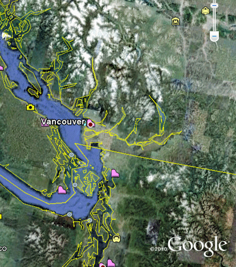
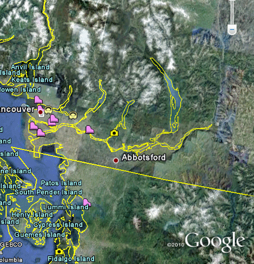
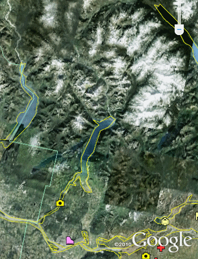
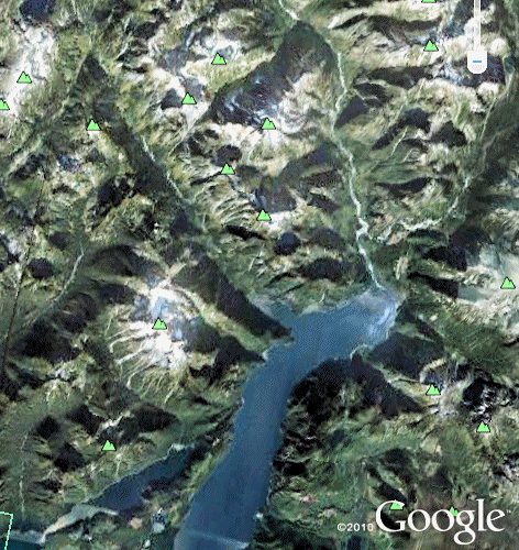
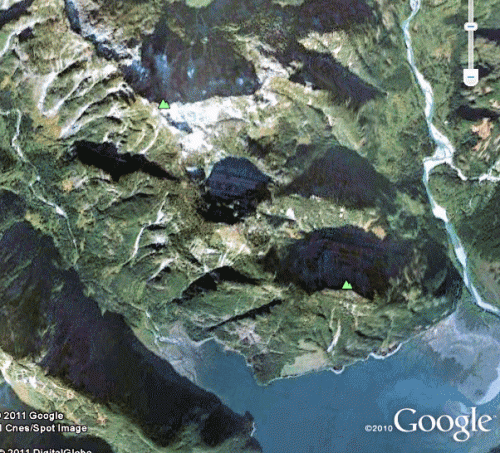
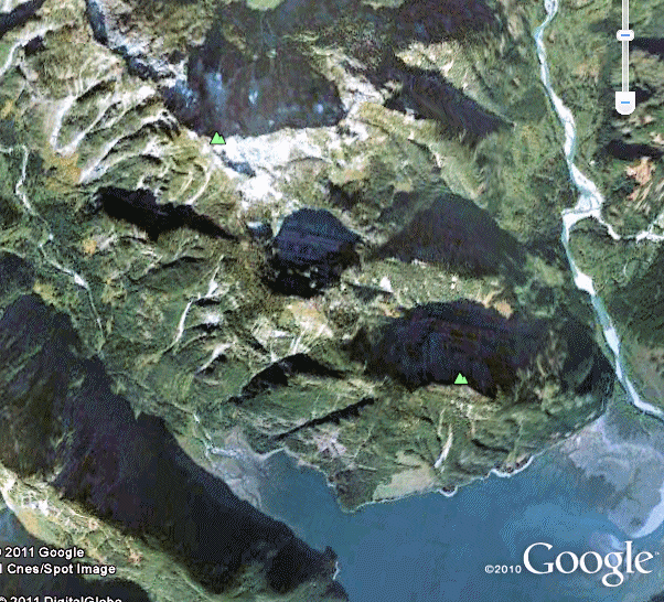
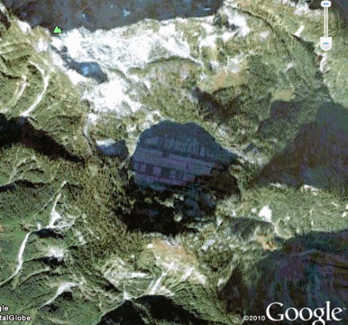
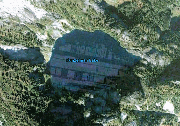
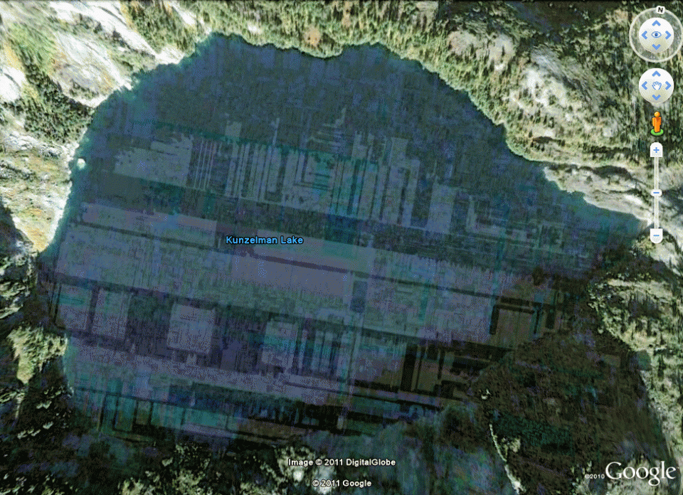
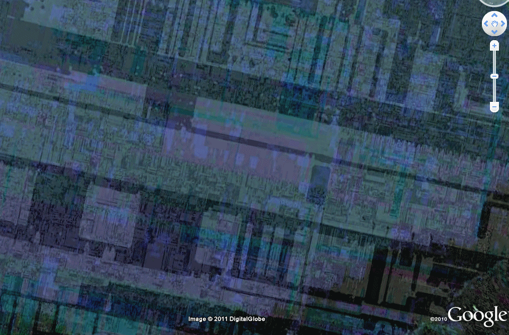
The point of this introduction is that some forty six years later I decided to take a look at the area in Google Earth to see what a keen eye in the sky might turn up. It didn't turn up the lost Indian's gold mine, but It sure as heck turned up a surprise that is maybe even more intriguing.

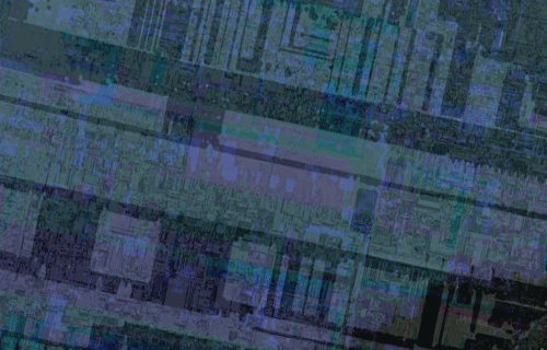
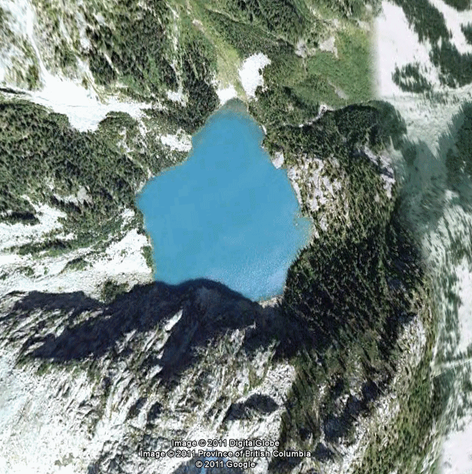
What it turned up looks for all the world like the image of a micro chip circuit board sitting right in the middle of a tiny mountain top lake just north east of Vancouver British Columbia.

bbb

  The main area of interest is just east of Vancouver along the Fraser River.

 Fig. 2

  The central area of interest is Stave Lake, the middle lake due north of Abbotsford.

 Fig. 3

The particular area of interest is into the mountains just north of Stave Lake.

Fig. 4

The specific area of interest is just above the north tip of Stave Lake

Fig. 5

  The exact area of interest is Kunzelman Lake, a tiny round lake above the tip.

Fig. 6


Figs 7 to 11 are progressive expansions of Kunzelman Lake.


Fig. 7


Fig. 8


Fig. 9


Fig. 10


Fig. 11


And there you have it, for all the world the image of a microchip printed circuit board imprinted onto the surface of the lake. Is this the modern way spies are passing clandestine information to each other. If it isn't, then what the heck is it. What a plot for a movie.

.
 

As to not leave the impression that the circuit board effect is a standard way that Google treats the surfaces of any small mountainous lake, the following lake even smaller than Kunzleman Lake, sitting exactly due north of the right top tip of Stave lake. As you can see, perfectly normal. Nuff said.


THE BOTTOM LINE


There are numerous other areas within this tight region around the end of Stave Lake which have the same colouration. None however come even close to the same clarity of content and definition as Kunzleman Lake..

It is also interesting to note that a search of other mountainous regions around the world, including the Andes and Himalayans, significantly fail to turn up even the simple colourations. So the question is, is this for real, or did the Google camera just somehow manage to spill out its circuit guts for just this one particular location, perfectly centered on the surface of just this one small lake.

The fact is, whether this is a for real International Intrigue event, or simply some kind of extremely bizarre technical aberration in the photography, what a movie plot it would making staring Keanu Reeves and Sandra Bullock. If so I claim all proprietary rights for the idea in all possible variations, 'first knowledge' proved prima facie by the fact of this presentation. If you want to talk to me about it please email me at cliflive@rogers.com. The highest bidder gets the rights.

I mean think about it for a moment, the intrigue of the situation is enormous. Si Fi or for real, all you would have to do is send someone the longitude and latitude coordinates for a single pixel in Google Earth in order to locate an imbedded message who else would ever know.

And how would this be accomplished. Would somebody inside Google have to be in on it. Would hackers have to hack themselves inside the loop to insert the information. Would somebody have to highjack the satellite signal and send it to England to have the information placed inside then send it back out.

The juicy plot possibilities are endless, even to the extent of Aliens sending covert messages to each other over Google Earth. If it is in fact a real microchip image, then the possibilities are even more intriguing.

Somebody should contact Google and see what they have to say about it.

The point of the lost gold mine story is that if it hadn't been for the fact that I had been actually prospecting up in the area some forty six years ago, I would never have gone looking in the area on Google Earth and would never have discovered the circuit board covering the surface of Kunzleman Lake. And if it really is spies, their secret would have remained likely undiscovered forever, good as gold.

Whether for real or for fun, if you think this discovery is worthy of it please pass it on to any news website you might know or be dealing with, plus tweet your followers and share with your friends. Help it go viral.

(c) Cliff Livingstone, Canada, 2011.


VIEW THE AREA IN 3D


To get an idea of how really rough the area is, Notice the slew of emerald glaciers sitting just to left of the end of Slave Lake, not forgetting that the lake is essentially as sea level. Notice also the small emerald glaciations just south of Kunleman Lake. This is very up and down terrain. This whole area and going north is no small potatoes. Small wonder it wasn't surveyed until recently.

To see how high up in the top of its mountain Kunzleman Lake is actually sitting, and get a real time idea of how staggeringly rough the whole terrain is in there, view it in full IMAX 3D effect. It is simple to do but a bit tricky to get started the first time.

Expand the area in Google Earth to about the amount of Fig. 8, then give Google Earth a slight tug with your mouse to get the view slowly scrolling across the page. If the view is not expanded enough it won't start scrolling. If it is too large, it will scroll faster and faster then revert into Google Earth's patented horizontal surface level view mode. If it is scrolling too slow, the 3D effect will be minimal. If too fast, you won't be able to process the information properly.

It doesn't matter which direction you scroll it. If you hit the combination of expansion and speed of scroll just just right, the terrain will roll across your screen in perfect 3D, all done courtesy of your brains' real time internal processing capability of what it sees and having nothing to do with Google Earth itself.

The procedure is not patent. It is simply a matter of getting everything just right. You will likely have to play around with it for awhile before you get it. If the view is not expanded enough it will not start scrolling. If it is too large, it will scroll faster and faster then revert into Google Earth's horizontal surface level view mode.

 If it is scrolling too slow, the 3D effect will be minimal. If too fast, you won't be able to process the information properly. But once you get it you got it, and thus forever have it. You can do this with any highly vertical terrain including the Grand Canyon.

Once you get it it is quite breathtaking actually, makes you think you are watching an IMAX.

(c) Cliff Livingstone, Canada, 2011 - 2012.

Check out the www.pfur.com home Page!


[an error occurred while processing this directive]

Daily Quark

[an error occurred while processing this directive]

More

[an error occurred while processing this directive]

Daily Question

[an error occurred while processing this directive]

More

[an error occurred while processing this directive]

PREFERRED STUFF

Spiritual Largess

What are Soul Mates
What is Free Will
Are There Other Dimensions
Spiritual Thumbnails
Does God Exist
Universal Principle of Tithe 
Intelligent Design


Make pfur.com Your home Page


   Daily Riddle

More
 
[an error occurred while processing this directive]

RESERVED FOR ADDITIONAL BOOKMARKS

Daily Factoids

[an error occurred while processing this directive]

[an error occurred while processing this directive]

[an error occurred while processing this directive]

More

Daily Answer

[an error occurred while processing this directive]

More

Daily Definition

[an error occurred while processing this directive]

More

Helpful Tip

[an error occurred while processing this directive]

Daily Quip

[an error occurred while processing this directive]

More

[an error occurred while processing this directive]